


")


")


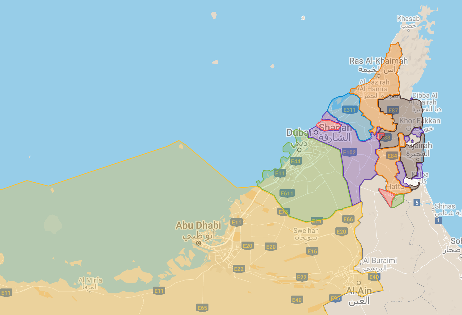
When I arrived in the United Arab Emirates (UAE), I couldn’t find any good maps of the borders between the seven emirates. There are plenty of good maps of Abu Dhabi and Dubai, but nothing about the lesser-known emirates such as Sharjah, Ajman, Umm Al Quwain, Ras Al Khaimah, and Fujairah. I wanted to give them some attention in this post.
All these emirates have their own rulers and their own borders. These function like state borders. They’re inherited from the predecessor country before 1971, called the Trucial States. During this year’s (2021) National Day, the UAE will celebrate its 50th anniversary.
However, on the ground, there are no road signs that say “Welcome to Fujairah” to let you know where you are. I think this is because the focus within the country lies on united and not individual emirates. All emirates except for Umm Al Quwain and Abu Dhabi have one or more exclaves. The most interesting exclave is the Madha–Nahwa ‘donut’ between the emirate of Sharjah and Oman. This makes the map of them a very complicated puzzle. But I love map-making and puzzling, so I decided to make a map – mostly for personal use – of the borders between the seven emirates. After all that labor, I thought it would be silly not to share it with the world.
Use the menu button in the top left to see the menu of emirates. The longer you stare, the more odd border situations you’ll see. Enjoy the map:

Disclaimer: this map has mistakes and I don’t mean to offend anyone. I used many different sources to create this map. It’s far from perfect. I mapped them in the following order: Ajman, Sharjah, Dubai, Abu Dhabi, Umm Al Quwain, Ras Al Khaimah, Fujairah. The biggest flaws are in the borders between Ras Al Khaimah, Fujairah, and Sharjah on the east coast. I also included a section about the disputed areas between the UAE and Iran (three islands) and Abu Dhabi and Saudi Arabia. Please don’t get mad.
Helpful? Consider buying me a Qahwah Arabiyya!


Donate via PayPal

Anything to Add to this Map?
I’d love to hear your suggestions in the comments of what else to add to this map. Or if you think you can make a better map, I invite you to copy it and improve it. In that case, please send me a link to the improved map 🙂
Similar posts:
 Two Weeks in Dubai (United Arab Emirates)
 Sheikh Zayed Grand Mosque, Fujairah—How to Visit as a Non-Muslim
 Two Weeks in Sharjah + Ajman (United Arab Emirates)
 Madha and Nahwa Exclaves in Oman + UAE—Traveling Through the Donut Hole
 Manama, Ajman — Visiting the Inland Exclave + Al Dhaid as a Day Trip from Sharjah
Great job….
First off, wow, this map is 100% awesome and I love it. I did notice that the eastern border of Ajman is too far east. The areas marked as Hay al Dibdibah North and South are in Sharjah.
Hey Alan, yeah I see that neighborhood isn’t in Sharjah (anymore). Made this map many years ago based on other maps. It’s updated now!
This is good work, i was looking for a kml to help me understand the complication in the north east !
Thanks.
Thanks! I hope you enjoyed the UAE, Oman, the Musandam Peninsula, and the Omani Donut 🍩 I’m still hoping to go back there one day when the borders work like usual
The Ajman enclave shared with Dubai is wrong, much more intricate
Hey Lucas, thanks for your comment. I think you’re talking about Ajman’s Masfout/Masfut/مصفوت exclave next to Dubai’s Hatta. My map sources give multiple answers as to how the border goes in that area and five years ago when I made this post, I picked one answer you can still see today. I see Masfout is having a moment of tourist popularity, at least in 2025 before the current situation. Feel free to link your source of the much more intricate border map of Ajman’s Masfout. I am curious what your version is.
Happy travels