")
")


 is Canceled")


The Intention
We’d been in São Nicolau for four days. I really wanted to hike up Monte Gordo, the highest point of the island before we arrived. When we flew in from Sal, I already spotted the peak piercing through a thick layer of clouds from my plane seat.
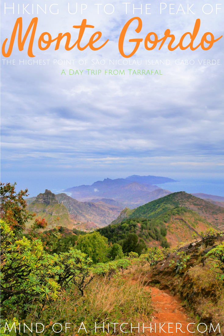
Monte Gordo (‘fat mountain’) is the highest point of São Nicolau island, Cabo Verde. It’s 1312 meters high , and of volcanic origin. But don’t worry, it’s dead now. It’s a protected area inside the Parque Natural de Monte Gordo. While São Nicolau is quite a dry island, the areas higher up were promised to be greener.
Our host Giuliani in Tarrafal climbs up Monte Gordo on the regular. He told us it takes about 2.5 hours to make the round trip from the park entrance to the peak and back. Giuliani said there’s a booth at the entrance where you’re supposed to pay an entry fee, but sometimes they’re not working, so then you can enter for free. The normal price would be something like 200 CVE, or ~€1.80 per person. Giuliani also suggested that if we didn’t want to pay, we could simply approach the peak from a different trail. Of course, we weren’t that desperate to not pay for conservation efforts.
Here’s my experience hiking to the top. It cost us 700 CVE (~€6.30)
Leaving Tarrafal de São Nicolau
These events happened on Sunday the 27th of January.
We walked to the main road out of Tarrafal in the morning, with a fully prepared day bag filled with bottles of water, yet-to-be-prepared sandwiches, toppings, and snacks. We’d see if we could hitch a ride, or catch an aluguer to Cachaço. There were many people dressed in black or muted colors, as we walked past the church: a Sunday funeral.
We ran into Roberto – the Italian who runs a quad rental – and asked him to ask a local how much we should pay for the aluguer to this village along the way. He came back with an estimate of 120 CVE per person or 250 CVE for the both of us.
At the road next to the Enacol gas station, there were a few empty Hiace’s and Hiluxes beeping at us, urging to ride with them. If they’re empty, it means they won’t leave until they’re full, which means you could still leave much later. We waited until a vehicle that was actually driving off came by.
A few private vehicles passed, but they didn’t stop for our thumbs. Then, an old Hilux drove up to us with one passenger in the back. I ask the guy in the passenger seat “A Cachaço?” (Ca-tcha-so) and he answers with an affirmative, and repeats back “Cachaço”, revealing the real pronunciation (Ca-sha-so). The more you know. We hopped in the trunk.
“Bom dia,” we say to our fellow passenger, to which he replies with “Bon dia”. We’re still struggling with Portuguese, let alone the local Portuguese Creole. The young guy is also dressed in neatly pressed clothes, presumably also for the funeral or church visit.
Winding Road
We drive up the mountains. This road is the main link between Tarrafal de São Nicolau, Ribeira Brava, and the airport near Preguiça. It’s largely asphalted, but very very twisty. I’m enjoying the ride a lot, with my hat on and the wind in my hair. Jonas is also doing fine, I think. At some point, we’re so high that we can see into the canyon that reveals the city of Ribeira Brava. It’s a truly terrifying drop.
We follow on my offline map app the villages we go through. There’s the symbol of a cocktail bar on the crossing where we need to go out, but we’re pretty sure it’s not really a cocktail bar. We knock on the back window when we want to go out, and the car stops immediately. We say goodbye to our fellow passenger, climb out the trunk, and pay the driver. As stated, it cost 250 CVE – a fair price without arguing. The car drives off.
To our left is a sign announcing the natural park Monte Gordo. I tell Jonas about a little church nearby, and how there’s a lookout on our right-hand side, as the map says. I suggest we first visit that area before we hike up the mountain.
Two Lookouts
We first encounter another lookout, one that’s not on my map, so I add it. From here, you have beautiful vistas of Ribeira Brava. A road passes next to the viewpoint and a road sign indicates a shortcut down the valley to Ribeira Brava. It’s very zig-zaggy and would take courage whether on foot or with a vehicle. While we’re enjoying the lookout, two young girls in their school uniforms start their journey down that road. They wave at us and we wave back. it’s weird… do they go to school on a Sunday?
We hike on to the next lookout. I’m enjoying the scenery as we pass by some fields with low crops and some papaya trees. We see the little church named Senhora do Monte. There’s a cross on a rock, and from there, again, there are nice views of Ribeira Brava. We take photos as usual. Jonas sitting so close to the edge gives me the creeps.
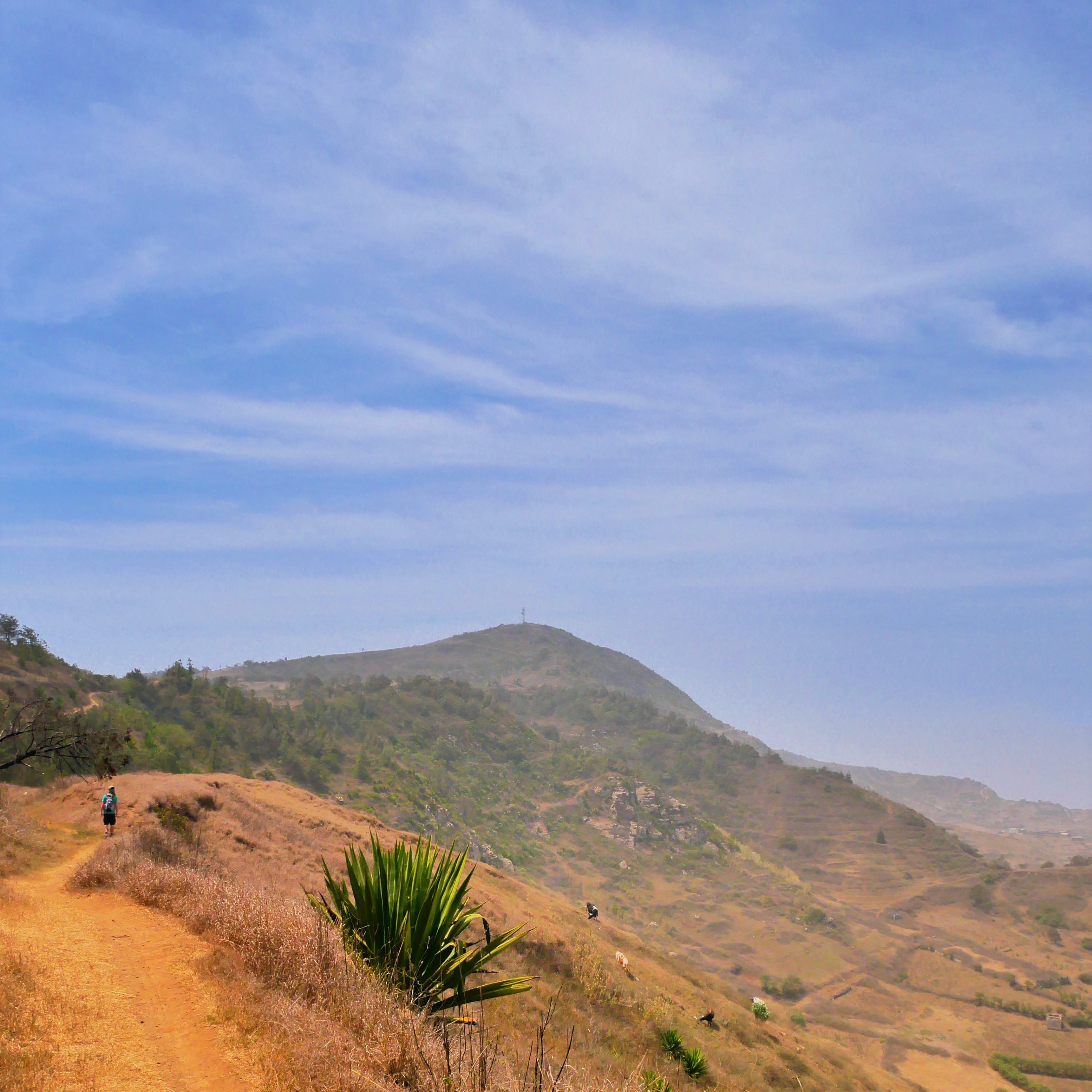
From here, you can see the trail that goes up to Monte Gordo pretty well. From here, we have no clue which peak exactly is Monte Gordo. Next, we walk back to the main road to finally enter the park.
Entrance Fee and Hike Up
Cachaço is at 712 meters, so the total ascent is 600 meters. The trail distance from this crossing is 3.4 kilometers. Some 300 meters into the high-quality park road, the Direçao do Parque Monte Gordo appears on the right-hand side. It’s a very nice and modern building, fully equipped with a wheelchair-friendly entrance. It’s weirdly ahead of the surroundings.
The lights are off, and no one’s there. So we walk past it without paying an entry fee. The whole town of Cachaço has actually been like that: abandoned save for a few souls. We conclude that they must all be at the funeral in Tarrafal. It was probably a very important and beloved person to draw out such a crowd.
After the park entrance building, the road’s quality quickly abates. The road becomes much skinnier and much steeper – I need to take many breaks to catch my breath – and much greener. The trees become tall enough to provide us with shadow. There are still nice signposts informing that this is indeed the way to Monte Gordo or take a left here to go to Monte Vermelho instead. Very affirming, even without a map.
At some point, we walk past a second building complex and a closed gate to block vehicles. We walk past it and enter a zone full of trees next to a crater. There is a sign informing us what kind of plant we’re looking at: Tortolho (Euphorbia Tuckeyana). We continue the trail, which flattens a bit before the final ascent. Someone here has their farm. There are some donkeys and cows stationed at a stone structure. Downhill from the animals is the crater the sign talked about.
We’re almost at the crossing where the trail leads to the peak of Monte Gordo. There’s an unofficial lookout on our right-hand side. From there, I could see the faint evidence of a trail going up and in between two dramatic mountains. It’s possible to see a small structure in the flat area between the two summits. I’d later learn this is a village named Covoada, whence a trail connects to Ribeira Funda.
Final Stretch
We take the side trail to the final ascent. There’s another signpost telling us this bit is 1.2 kilometers long and climbs 262 meters. I’m impressed by the maintenance here. Jonas takes the backpack and leads. First, it starts with some stairs. Then as the trees thin out, the trail flattens and tacks back and forth.
When all the trees are gone, the ground becomes this loose kind of rubble – the kind that turns a full step into a half step because you’re slipping – and I know that this will be a shitshow for me on the way down. A fellow foreigner comes down the mountain as we go it up. He only carries a plastic bag for his minimal stuff. We greet as he confidently walks down what to me is slippery as heck.
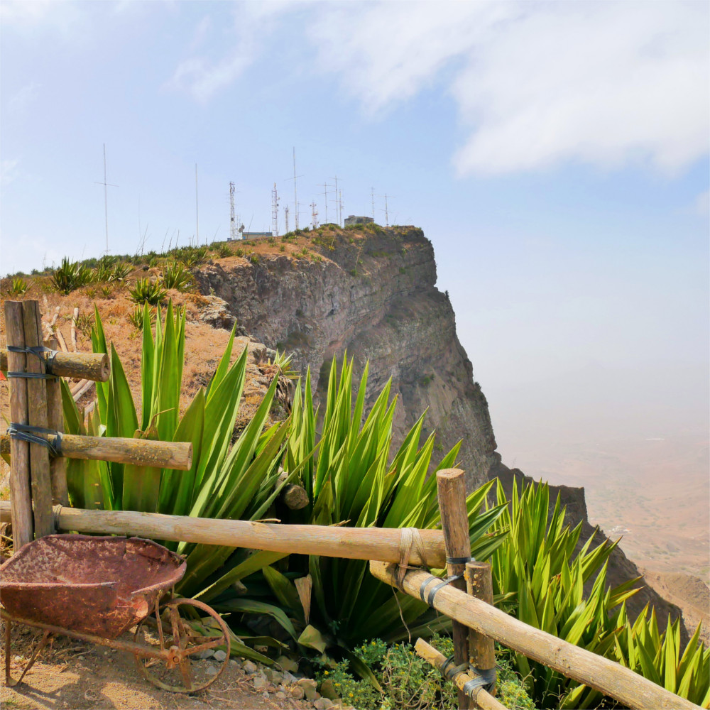
Our efforts are rewarded with some breathtaking views. A power line follows our trail towards the top. It feeds the antenna’s that provide us with mobile coverage and the weather station. The wind picks up and I tighten my hat. It’s a little scary when looking down. Once at the top, there’s again a sign with pictures informing us what we’re looking at. It’s funny to us that the pictures on there were taken on a day much less clear than today.
At the Peak of Monte Gordo
We high-five, as per usual.
To the south, we see all of Tarrafal and the southern peninsula of São Nicolau – a place I think is named Península de Fidalgo that features a mountain called Tope da Mesa. To the west, we could see the two uninhabited islets Ilhéu Raso and Ilhéu Branco, the also uninhabited island Santa Luzia and our next island: São Vicente. I swear I could even see a faint line of Santo Antão on this clear day.
To the east, we had a pretty good view again of the Ribeira Brava valley. Monte Vermelho blocked the view to Preguiça and the airport, but we did see a plane take off from the valley. Further east, we could see the land’s end near Carriçal. To the north, we could see the green farming area and again the road to Covoada.
A Rainy Lunch
We walked around the antenna’s and structures looking for a place to eat. Yes, it was a good day to do this hike because of the amazing views, but it was also cloudy, much higher up. When we found a spot facing west to eat our lunch, it started to drizzle. The kind that irritates you enough to move. Jonas walked around trying all the doors, seeing if we could find some shelter, but it was all locked. We put our tech in my dry bag and chose the wall of a building sheltered from the wind and a little from the rain.
We grab our loaves, a jar of peanut butter, and some Guave marmelo, which is the Portuguese name for what we know as the Argentinian membrillo. I’m not big on the sweet stuff, but Jonas loves it. This is technically our breakfast, and boy we’re hungry.
We eat until maximum capacity and chug a lot of water. After about half an hour at the top, we prepare to return. I grab the backpack.
The Hike Down
Downhill isn’t my strong suit; I keep slipping on loose rubble, no matter what technique I use. Jonas takes the backpack for the worst part. In this moment, I don’t really feel like I’m living my best life; my body is a source of disappointment.
When we’re out of the shitty zone, I take the backpack again. Once again at the crossing, we discuss whether we want to continue the hike to Praia Branca or even Ribeira da Prata, or return to Cachaço. This would be a nice trip without backtracking, but after doing some map research, we decide not to go to Praia Branca. It would be another 6.6 kilometers and a 900 meter descend to the nearest paved road in Praia Branca, and probably a lot further still.
We backtrack to Cachaço and encounter a French family on the way. The people of São Nicolau always assumed we’re French, but these are the first French people we actually see in Cabo Verde. Father, mother, and daughter are also going up to Monte Gordo. He looks excited and energized, while the other two are already sick of it. The child complains audibly.
Further down, a woman with a gas canister in a basket on her head walks up, while we go down. We say hello, and she puts down her basket and begs Jonas for money. We say no and continue downward, but she keeps wailing at us in a heartbreaking tone for another full two minutes while we’re walking away. This is the first time someone asked us for money in Cabo Verde.
Waiting for a Ride
We arrive back at the entrance building and visitor’s center. The lights are still off. It took us 3.5 hours to do the return trip, which I think isn’t so bad considering we took it easy. Back at the crossing, we enter the ‘cocktail bar’ on our map. There are some men drinking beer outside on the terrace. There’s a red Hiace aluguer parked in front of the store. Jonas asks a lady named Maria for a cold coke, and I pick a Maaza Guava drink. That will be 200 CVE. We sit on the wall outside, waiting for a vehicle to pass by.
There really isn’t much traffic this afternoon. Every now and then, a private vehicle passes by. I put up my thumb to hitchhike, but they don’t stop. One of the guys drinking a beer tells us that’s not how it works. Sometimes, a Hilux aluguer comes by, but without the ‘aluguer’ sign out. The guy tells us that this means that it’s not picking up customers right now. We don’t really understand these rules and symbols yet.
An older guy from the group asks us a couple of questions. We try our best to answer them in Portuguese and/or our interpretation of the Cabo Verdean Creole (Kriolo/Kriolu). We say we went to Monte Gordo, and he tells us how to say that in Kaboverdianu: “Bô bé Mont Gordo” . I repeat after him.
We wait there for more than half an hour, without any luck for an aluguer or hitch. Then the French people come down the path. The guy who told us we’re doing the aluguer-taking all wrong gets up and walks to the red Hiace. Apparently, the French people paid for the Hiace to be a private taxi. The driver talks to the French man to ask if it’s OK if we’re also coming and then waves at us to come. We take it and join in.
Back to Tarrafal de São Nicolau
Jonas speaks with the father in French about the hike. How were they so quick? The father answers that he left his wife and his kid somewhere below the summit, then hiked it up and down alone. This is also kind of how I remember family holidays to be: an enthusiastic party and an apathetic party.
Still, he did the whole thing in 1 hour and 15 minutes by my estimates. So quick!
Jonas and I are not sure what we’re supposed to pay now. Should we split the taxi costs with the French people? Do we just pay our 250 CVE as we did on the way to Cachaço?
We get dropped off at the port in Tarrafal. The French people pay first, and I see many bills being handed over. We would see the French people again a few weeks later in Mindelo’s marina, São Vicente island. Then we pay our 250 CVE directly to the driver. Nobody starts a discussion, so we consider it done and done. We celebrate our achievement with a beer in town.
Enjoyed This Story? Pin This Picture!